
Berkas:Hammurabi's Babylonia Locator Map 1.svg

Ukuran pratayang PNG ini dari berkas SVG ini: 671 × 600 piksel Resolusi lainnya: 269 × 240 piksel | 537 × 480 piksel | 859 × 768 piksel | 1.146 × 1.024 piksel | 2.291 × 2.048 piksel | 744 × 665 piksel.
Ukuran asli (Berkas SVG, secara nominal 744 × 665 piksel, besar berkas: 154 KB)
Ringkasan
| Deskripsi |
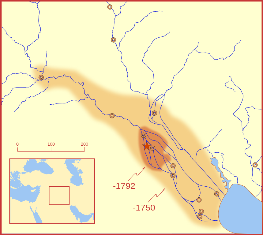
A locator map of Hammurabi's Babylonia, showing the Babylonian territory upon his ascension in 1792 BC and upon his death in 1750 BC. The river courses and coastline are those of that time period -- in general, they are not the modern rivers or coastlines. This is a Mercator projection, with north in its usual position. There is some question to what degree the cities of Nineveh, Tuttul, and Assur were under Babylonian authority. While in his introduction to his code of laws, Hammurabi claims lordship over these cities, Roaf does not include any of these in his map, upon which this map is based, and Chevalas states that "Assur and Nineveh were held for a very few years" (p. 155). Therefore, I have not included them as under Hammurabi's control in 1750 BC. |
| Tanggal | |
| Sumber | Karya sendiri |
| Pembuat | MapMaster |
| Versi lainnya |
[]
|


Other versions
References
- Bjorklund, Oddvar; Holmboe, Haakon; Rohr, Anders (1970) Historical Atlas of the World, Barnes & Noble, NY, SBN: 389-00253-4.
- Chavalas, Mark W.; K. Lawson Younger (2003) Mesopotamia and the Bible, Continuum International Publishing Group, ISBN 978-0567082312.
- Hammond World Atlas Corporation (2007) Historical World Atlas, ISBN 9-780843-71391-6
- Roaf, M. (1990) Cultural Atlas of Mesopotamia and the ancient Near East, Oxford: Facts on File. (In general, the basis for the ancient river courses and ancient coastline).
- Van De Mieroop, Marc (2005). King Hammurabi of Babylon: A Biography. Blackwell Publishing. ISBN 1405126604
Lisensi
Saya, pemilik hak cipta dari karya ini, dengan ini menerbitkan berkas ini di bawah ketentuan berikut:

|
Diizinkan untuk menyalin, mendistribusikan dan/atau memodifikasi dokumen ini di bawah syarat-syarat Lisensi Dokumentasi Bebas GNU, Versi 1.2 atau lebih baru yang diterbitkan oleh Free Software Foundation; tanpa Bagian Invarian, tanpa Teks Sampul Depan, dan tanpa Teks Sampul Belakang. Salinan lisensi dimasukkan ke bagian yang berjudul Lisensi Dokumentasi Bebas GNU. |
This file is licensed under the Creative Commons Attribution-Share Alike 4.0 International, 3.0 Unported, 2.5 Generic, 2.0 Generic and 1.0 Generic license.
- Anda diizinkan:
- untuk berbagi – untuk menyalin, mendistribusikan dan memindahkan karya ini
- untuk menggubah – untuk mengadaptasi karya ini
- Berdasarkan ketentuan berikut:
- atribusi – Anda harus mencantumkan atribusi yang sesuai, memberikan pranala ke lisensi, dan memberi tahu bila ada perubahan. Anda dapat melakukannya melalui cara yang Anda inginkan, namun tidak menyatakan bahwa pemberi lisensi mendukung Anda atau penggunaan Anda.
- berbagi serupa – Apabila Anda menggubah, mengubah, atau membuat turunan dari materi ini, Anda harus menyebarluaskan kontribusi Anda di bawah lisensi yang sama seperti lisensi pada materi asli.
Anda dapat memilih lisensi pilihan Anda.
Riwayat berkas
Klik pada tanggal/waktu untuk melihat berkas ini pada saat tersebut.
| Tanggal/Waktu | Miniatur | Dimensi | Pengguna | Komentar | |
|---|---|---|---|---|---|
| terkini | 21 Februari 2008 03.26 | | 744 × 665 (154 KB) | MapMaster | "blurred" the territory outlines |
| 20 Februari 2008 23.22 |  | 744 × 665 (149 KB) | MapMaster | Changes based on a review of ''Mesopotamia and the Bible'' | |
| 20 Februari 2008 22.10 |  | 744 × 665 (151 KB) | MapMaster | Minor edits | |
| 19 Februari 2008 03.03 |  | 744 × 665 (150 KB) | MapMaster | Once more, with feeling | |
| 19 Februari 2008 02.09 |  | 744 × 665 (151 KB) | MapMaster | earlier upload would not render | |
| 19 Februari 2008 02.01 |  | 332 × 292 (333 KB) | MapMaster | {{Information |Description=A locator map of Hammurabi's Babylonia, showing the Babylonian territory upon his ascension in 1792 BC and upon his death in 1750 BC. The river courses and coastline are those of that time period -- in general, they are not the |
Penggunaan berkas
2 halaman berikut menggunakan berkas ini:
Penggunaan berkas global
Wiki lain berikut menggunakan berkas ini:
- Penggunaan pada bg.wikipedia.org
- Penggunaan pada bs.wikipedia.org
- Penggunaan pada cs.wikipedia.org
- Penggunaan pada da.wikipedia.org
- Penggunaan pada el.wikipedia.org
- Penggunaan pada eo.wikipedia.org
- Penggunaan pada et.wikipedia.org
- Penggunaan pada fi.wikipedia.org
- Penggunaan pada fr.wikipedia.org
- Penggunaan pada gl.wikipedia.org
- Penggunaan pada he.wikipedia.org
- Penggunaan pada hr.wikipedia.org
- Penggunaan pada hu.wikipedia.org
- Penggunaan pada it.wikipedia.org
- Penggunaan pada ja.wikipedia.org
- Penggunaan pada jv.wikipedia.org
- Penggunaan pada lt.wikipedia.org
- Penggunaan pada lv.wikipedia.org
- Penggunaan pada nl.wikipedia.org
- Penggunaan pada no.wikipedia.org
- Penggunaan pada pl.wikipedia.org
- Penggunaan pada pt.wikipedia.org
- Penggunaan pada ro.wikipedia.org
- Penggunaan pada ru.wikipedia.org
- Penggunaan pada sh.wikipedia.org
- Penggunaan pada sl.wikipedia.org
- Penggunaan pada sq.wikipedia.org
- Penggunaan pada sv.wikipedia.org
- Penggunaan pada sw.wikipedia.org
- Penggunaan pada tr.wikipedia.org