
Berkas:EasternSolomonsChart.jpg
Ukuran pratayang ini: 559 × 599 piksel. Resolusi lainnya: 224 × 240 piksel | 448 × 480 piksel | 640 × 686 piksel.
Ukuran asli (640 × 686 piksel, ukuran berkas: 90 KB, tipe MIME: image/jpeg)
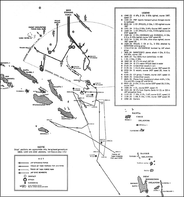
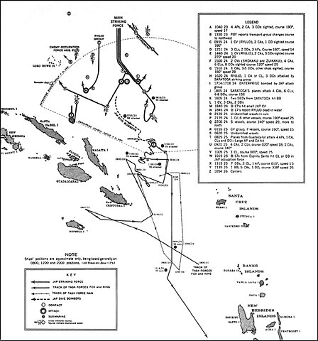
| Deskripsi | US Navy map of The Battle of the Eastern Solomons. Tracks of Allied (U.S.) forces are most likely fairly accurate. Tracks of Japanese forces are approximate and/or conjectured. The term "Jap" is used as shorthand for "Japanese" on the map. It's unknown whether this was used pejoratively in this publication or as an accepted abbreviation at that time. |
| Tanggal | |
| Sumber | US Government ( http://www.ibiblio.org/hyperwar/USN/USN-CN-ESols/index.html )The Battle of the Eastern Solomons, 23-25 August 1942, Navy Department Office of Naval Intelligence, Combat Narrative |
| Pembuat | US Government |
| Izin (Menggunakan kembali berkas ini) |
US Government/public domain |
This file is a work of a sailor or employee of the U.S. Navy, taken or made as part of that person's official duties. As a work of the U.S. federal government, it is in the public domain in the United States.
|
 | |
| Berkas ini telah diidentifikasi bebas dari pembatasan menurut hukum hak cipta termasuk semua hak terkait dan relevan. | ||
Riwayat berkas
Klik pada tanggal/waktu untuk melihat berkas ini pada saat tersebut.
| Tanggal/Waktu | Miniatur | Dimensi | Pengguna | Komentar | |
|---|---|---|---|---|---|
| terkini | 24 Mei 2006 16.12 | | 640 × 686 (90 KB) | Cla68 | {{Information| |Description= US Navy map of The Battle of the Eastern Solomons. This map may not be entirely accurate since it was published before World War II was over. |Source= US Government (http://www.ibiblio.org/hyperwar/USN/USN-CN-ESols/index.html |
Penggunaan berkas
Halaman berikut menggunakan berkas ini:
Penggunaan berkas global
Wiki lain berikut menggunakan berkas ini:
- Penggunaan pada azb.wikipedia.org
- Penggunaan pada cs.wikipedia.org
- Penggunaan pada da.wikipedia.org
- Penggunaan pada en.wikipedia.org
- Penggunaan pada es.wikipedia.org
- Penggunaan pada fr.wikipedia.org
- Penggunaan pada he.wikipedia.org
- Penggunaan pada hu.wikipedia.org
- Penggunaan pada ko.wikipedia.org
- Penggunaan pada nl.wikipedia.org
- Penggunaan pada sr.wikipedia.org
- Penggunaan pada vi.wikipedia.org
- Penggunaan pada zh.wikipedia.org