
Berkas:Carte de ukraine 1919.jpg

Ukuran pratayang ini: 800 × 508 piksel. Resolusi lainnya: 320 × 203 piksel | 640 × 406 piksel | 934 × 593 piksel.
Ukuran asli (934 × 593 piksel, ukuran berkas: 305 KB, tipe MIME: image/jpeg)
Ringkasan
| Deskripsi |
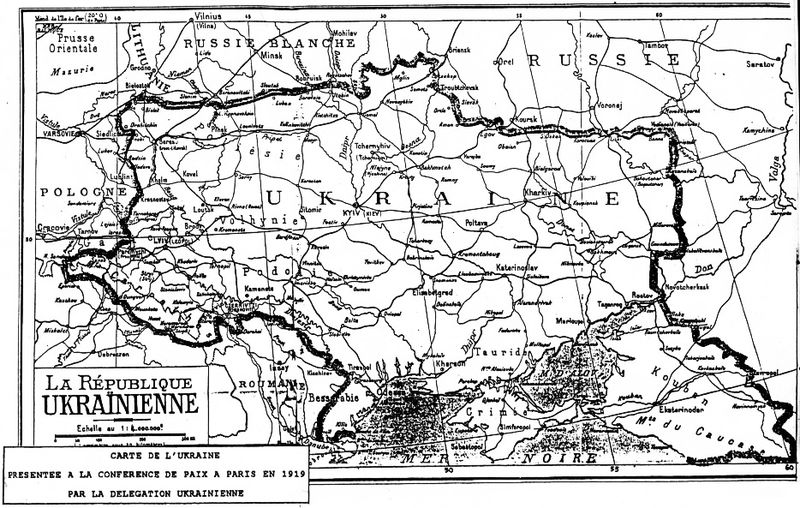
Deutsch: Grenzziehung der Ukrainischen Republik, wie sie von der ukrainischen Delegation auf der Pariser Friedenskonferenz 1919 präsentiert wurde
English: Map of Ukraine presented by Ukrainian delegation on Paris Peace Conference, 1919
Українська: Межі України, які були заявлені делегацією УНР на Паризькій мирній конференції в 1919-20 рр. |
| Tanggal | 1919 |
| Sumber | direct source:Documents of Paris Peace Conference 1919 see also :"Akten zur deutschen auswärtigen Politik 1918-1945" Ser. A, 1918-1925. Bd. 1, 9. November bis 5. Mai 1919 Göttingen : Vandenhoeck und Ruprecht, 1982. |
| Pembuat | Government of ZUNR in name of ZUNR and UNR, official document of government of Ukraine |
| Versi lainnya |
|


Lisensi
This file is a Ukrainian or Ukrainian SSR work and it is presently in the public domain in Ukraine, because it was published before January 1, 1954, and the creator (if known) died before that date (details).
|
 |
Riwayat berkas
Klik pada tanggal/waktu untuk melihat berkas ini pada saat tersebut.
| Tanggal/Waktu | Miniatur | Dimensi | Pengguna | Komentar | |
|---|---|---|---|---|---|
| terkini | 2 Oktober 2011 00.48 | | 934 × 593 (305 KB) | Yerevanci | better version |
| 8 Maret 2008 01.49 |  | 934 × 593 (194 KB) | Riwnodennyk | {{Information |Description={{en|Map of Ukraine perposed by Ukrainian delegation on Paris Peace Conference, 1919}} |Source=[http://uk.wikipedia.org/wiki/Зображення:Carte_de_ukraine_1919.jpg Ukrainian Wikipedia] |
Penggunaan berkas
Tidak ada halaman yang menggunakan berkas ini.
Penggunaan berkas global
Wiki lain berikut menggunakan berkas ini:
- Penggunaan pada be-tarask.wikipedia.org
- Penggunaan pada et.wikipedia.org