
Berkas:KYphysiography.jpg

Ukuran pratayang ini: 800 × 353 piksel. Resolusi lainnya: 320 × 141 piksel | 824 × 364 piksel.
Ukuran asli (824 × 364 piksel, ukuran berkas: 159 KB, tipe MIME: image/jpeg)


Ringkasan
| Deskripsi |
English: I created this image using Wikipedia's map of Kentucky counties.
|
| Tanggal | 1 Mei 2007 (original upload date) |
| Sumber | Dipindahkan dari en.wikipedia ke Commons oleh byankno1. |
| Pembuat | Lamontacranston di Wikipedia bahasa Inggris |
Lisensi
| Karya ini dilepaskan ke domain umum oleh pemiliknya, Lamontacranston di Wikipedia bahasa Inggris. Lisensi ini berlaku di seluruh dunia. Di sejumlah negara, tindakan ini tidak memungkinkan secara sah; bila seperti itu: Lamontacranston memberikan siapa pun hak untuk menggunakan karya ini untuk tujuan apa pun, tanpa persyaratan apa pun, kecuali yang ditetapkan oleh hukum. |
Log pengunggahan asli
Halaman deskripsi aslinya ada di sini. Semua nama pengguna berikut merujuk pada en.wikipedia.
- 2007-05-01 00:01 Lamontacranston 824×364× (162592 bytes) Bigger fonts. I created this image.
- 2007-04-30 23:54 Lamontacranston 824×364× (154693 bytes) Added text, improved edges, slightly lightened colors. I created the original.
- 2006-09-09 19:16 Lamontacranston 824×364× (55286 bytes) I created this image using Wikipedia's map of Kentucky counties.
Riwayat berkas
Klik pada tanggal/waktu untuk melihat berkas ini pada saat tersebut.
| Tanggal/Waktu | Miniatur | Dimensi | Pengguna | Komentar | |
|---|---|---|---|---|---|
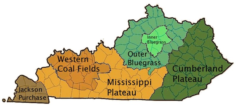
| terkini | 18 November 2008 16.36 | | 824 × 364 (159 KB) | EpcotMagic | {{Information |Description={{en|I created this image using Wikipedia's map of Kentucky counties. *Dark green - Eastern Kentucky Coal fields (Cumberland Plateau) *Green - Outer Bluegrass *Light Green - Inner Bluegrass *Light Brown - Mississippi (Pennyroyal |
Penggunaan berkas
Halaman berikut menggunakan berkas ini:
Penggunaan berkas global
Wiki lain berikut menggunakan berkas ini:
- Penggunaan pada ar.wikipedia.org
- Penggunaan pada de.wikipedia.org
- Penggunaan pada el.wikipedia.org
- Penggunaan pada en.wikipedia.org
- Penggunaan pada es.wikipedia.org
- Penggunaan pada fi.wikipedia.org
- Penggunaan pada he.wikipedia.org
- Penggunaan pada ia.wikipedia.org
- Penggunaan pada it.wikipedia.org
- Penggunaan pada ja.wikipedia.org
- Penggunaan pada no.wikipedia.org
- Penggunaan pada pt.wikipedia.org
- Penggunaan pada sh.wikipedia.org
- Penggunaan pada simple.wikipedia.org
- Penggunaan pada sv.wikipedia.org
- Penggunaan pada vi.wikipedia.org
- Penggunaan pada zh.wikipedia.org